
lunes, 31 de agosto de 2020
domingo, 30 de agosto de 2020
sábado, 29 de agosto de 2020
viernes, 28 de agosto de 2020
Practicas IFR en SCEL
A3237/20A02 NOTAMR A3236/20
Q)SCEZ/QATLT/IV/NBO/AE/000/999/3324S07048W005
A)SCEL B)2008201626 C)2008272100
D)DLY BTN 1400-1600/1800-2100
E)
ENGLISH VERSION
IFR PRACTICES CAN BE AUTHORIZED AT SCEL, WITH THE RATINGS MANTEINANCE PURPOSES ONLY.AIRPORT MUST BE IN VMC. ONE ACFT EVERY TIME. PILOTS MUST COORD. PREVIOUSLY WITH ACCS OPERATIONS MANAGER BY PHONE (MON-FRI) 22836 4018, (SAT-SUN-HOL) 22836 4017.
THE FOLLOWING MUST BE COMPLIED WITH: DERIVED FROM THE MEASURES ADOPTED BY THE AUTHORITIES, NO AIRCRAFT WILL BE ABLE TO ENTER OR EXIT OR OVERFLY THE COMMUNES IN QUARANTINE EXCEPT FOR QUALIFIED EXCEPTIONS. IN THESE CASES THEY MUST PRESENT THE FLIGHT PLAN INDICATING IN THE BOX 18, REASON FOR THE FLIGHT AND SEND THE DOCUMENTS ARRANGED BY THE SANITARY AUTHORITY AND OTHERS THAT MAY BE NECESSARY TO MOVE, VIA EMAIL TO ARO.COVID (ARROBA) DGAC.GOB.CL, PLACING IN THE SUBJECT OF THE MESSAGE THE REGISTRATION OF THE AIRCRAFT. WILL NOT BE CURSED NO FPL UNTIL RECEIVING SUCH DOCUMENTATION. FOR MORE INFORMATION ENTER THE WEBSITE.
HTTPS://WWW.GOB.CL/CORONAVIRUS
SPANISH VERSION
SE PODRA AUTORIZAR PRACTICAS IFR A SCEL CON EL PROPOSITO DE MANTENCION DE HABILITACION DE PILOTOS. AP DEBE ESTAR EN VMC. UNA ACFT POR VEZ, PREVIA COOR CON OPERACIONES ACCS FONO (MON-FRI)22836 4018, (SAT-SUN-HOL)22836 4017.)
//END PART 01//
(A3237/20B02 NOTAMR A3236/20
Q)SCEZ/QATLT/IV/NBO/AE/000/999/3324S07048W005
A)SCEL B)2008201626 C)2008272100
D)DLY BTN 1400-1600/1800-2100
E) SE DEBERA CUMPLIR CON LO NXT: DERIVADO DE LAS MEDIDAS ADOPTADAS POR LAS AUTORIDADES NINGUNA ACFT PODRA ENTRAR NI SALIR NI SOBREVOLAR LAS COMUNAS EN CUARENTENA SALVO EXCEPCIONES CALIFICADAS. EN ESTOS CASOS DEBERAN PRESENTAR EL PLAN DE VUELO INDICANDO EN EL CASILLERO 18, MOTIVO DEL VUELO Y ENVIAR LOS DOCUMENTOS DISPUESTOS POR LA AUTORIDAD SANITARIA Y OTROS QUE SEAN NECESARIOS PARA DESPLAZARSE, VIA CORREO ELECTRONICO A ARO.COVID(ARROBA)DGAC.GOB.CL, COLOCANDO EN EL ASUNTO DEL MENSAJE LA MATRICULA DE LA ACFT. NO SE CURSARA NINGUN FPL HASTA RECIBIR DICHA DOCUMENTACION. PARA MAYOR INFORMACION INGRESAR AL SITIO WEB.
HTTPS://WWW.GOB.CL/CORONAVIRUS
jueves, 27 de agosto de 2020
miércoles, 26 de agosto de 2020
martes, 25 de agosto de 2020

lunes, 24 de agosto de 2020
Does RNAV Always Mean GPS?
By Colin Cutler
08/15/2020
RNAV Routes Have Been Around Since The 1970s
 eBay
eBay
Satellite Navigation Changed The Game

An FMS Uses It All
So, Does RNAV Always Mean GPS?
08/15/2020
Did you know that GPS isn't the only form of RNAV? While the two acronyms are often used interchangeably, there's a lot more to RNAV than just GPS.
RNAV, Defined
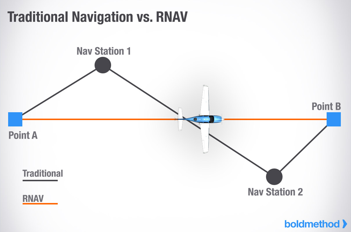
"Area Navigation" (RNAV) allows an aircraft to navigate between two points within the coverage zone of station-referenced navigation systems. Instead of having to go directly from one ground-based station to the next in a zig-zag pattern, RNAV allows aircraft to fly directly to any point within the coverage zone of the station being used. This "direct-to" capability often allows aircraft to bypass published routes, freeing up more airspace for traffic.
RNAV also allows aircraft to fly instrument approaches into airports that don't have any ground-based navigation stations, like a VOR or Localizer.
RNAV Routes Have Been Around Since The 1970s
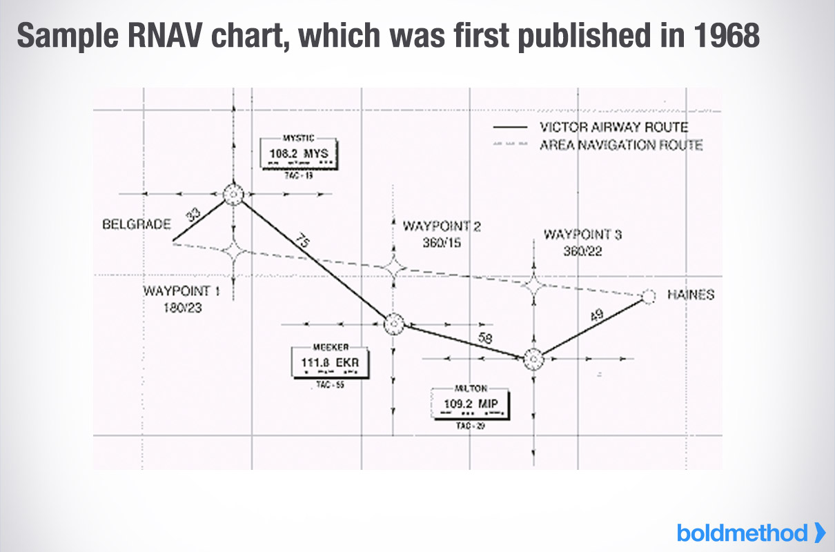
According to Jeppesen, the first RNAV en-route charts were published in 1968 when Narco introduced their CLC-60 RNAV computer to the market. This course-line-computer analyzed information from previously-installed VOR and DME receivers.
To use the CLC-60, two knobs controlled "radial" and "distance." If you wanted to "move" the VOR station 12 miles out on the 180 radial (this is just like creating a waypoint 12 miles to the South of a VOR), you'd set "180" in the radial window and "12" in the distance window. Unlike a standard VOR instrument, a full-scale deflection on the CLC-60 was 2 miles, whether you were 1 mile from the station or 50 miles from the station.
eBay
An RNAV route could be utilized by inputting a series of VOR Radials and DMEs to make a navigable course. Each "waypoint" of the course had an associated radial and DME from the VOR being used. Creating a direct route could shave off substantial mileage compared to victor airways, which rely on routes between NAVAIDs. For this to work, however, you needed to remain within the coverage limits of the VOR and DME.
Satellite Navigation Changed The Game
The first GPS satellite was launched in 1978 by the Department of Defense. Initially, GPS was only available for government and military use. But by 1993, a full 24-satellite constellation became operational and was opened to public use.
Using the same basic concept as VOR RNAV, as long as you're within the coverage range of GPS reception and your receiver is functioning properly, you can navigate point to point. For an aircraft to get a 3D location, the GPS receiver must get a reliable signal from 4 satellites simultaneously. With GPS available and accurate nearly all of the time, it's become the go-to source for RNAV navigation.
An FMS Uses It All
Flight Management Systems (FMS), which are typically found on business and airline jets, allow you to enter a series of waypoints and instrument procedures that define a flight route. If waypoints and procedures are included in the navigation database, the computer calculates the distances and courses between all waypoints in the route. During flight, the FMS provides precise guidance between each pair of waypoints, along with real-time information about aircraft course, groundspeed, distance, estimated time between waypoints, fuel consumed, and fuel/flight time remaining. While most FMS systems use GPS, that's not their only source of information.
Many FMS systems in large aircraft are linked to an Inertial Navigation Unit (often times called an Inertial Reference System, or IRS), which is comprised of lasers and gyros that determine aircraft flight path, altitude, and attitude. And that's not the only extra source of information for an FMS. Most FMS systems can use GPS, IRS, VOR, LOC, and DME receivers to provided position information to the FMS. If one form of navigation becomes unreliable, backup navigation aids can be used for continuous position information.

Approved RNAV Systems, And When To Use Them
According to the AIM these are a few RNAV systems that can be approved. Keep in mind, the specific equipment and certification goes far beyond this list:
Approved GPS Receivers
Flight Management Systems Integrating Multiple Navigation Sensors
RNAV System with DME/DME/IRU
DME/DME/IRU systems don't rely on GPS, and instead, utilize multiple DME stations and an Inertial Reference Unit to get position information. While GPS may initially provide the IRU with location information for calibration, it does not rely on GPS for operation.
What About RNP?
Required Navigation Performance (RNP) is a form of navigation that allows an aircraft to fly directly between two 3D points in space. The fundamental difference between RNP and RNAV is that RNP requires on-board performance monitoring and alerting capability. Think of this as a computer system that's constantly self-assessing and ensuring the reliability of navigation signals and position information.
According to GE Aviation, "RNP approaches with RNP values down to 0.1 allow aircraft to follow precise three-dimensional curved flight paths through congested airspace, around noise sensitive areas, or through difficult terrain." Specific testing and equipment are required to become RNP certified. Generally speaking, you won't fly RNP procedures until you're flying airline or corporate aircraft.
So, Does RNAV Always Mean GPS?
For most general aviation pilots today, yes. But that doesn't mean there aren't other forms of Area Navigation. In recent history, course line computers were the most basic form of RNAV. While GPS doesn't automatically equal RNAV, it's the most common system found in cockpits around the world, especially for piston aircraft.
domingo, 23 de agosto de 2020
The 7 Most Uncommon Instrument Approaches, And How They Work
1) Localizer Directional Aid Approach (LDA)
LDA approaches utilize a localizer that's simply offset from a runway centerline, often due to terrain.

Boldmethod
2) Precision Approach Radar (PAR)
A PAR approach is similar to an ILS. Both vertical and lateral navigation guidance is provided to the pilot, all without the use of navigation-reliant cockpit instrumentation. Air Traffic Controllers use radar to track the aircraft's position, then tell pilots over the radio what corrections they should make. These approaches are most commonly found at military bases around the country.

Boldmethod
3) Approach Surveillance Radar (ASR)
The only equipment required for an ASR approach is a functioning radio. The controller vectors the aircraft to align it with the runway centerline, and continues to do so until the aircraft can make a landing visually. It's flown in a similar fashion to many non-precision approaches, where step-down altitudes are used along the final approach path.

Live from the Flight Deck
4) Simplified Directional Facility Approach (SDF)
SDF approaches don't provide vertical guidance, and may or may not be offset from the runway's centerline. SDF signals are fixed at either 6 or 12 degrees wide, and usable off-course indications are limited to 35 degrees either side of the course centerline. The following airports continue to use SDF approaches in the USA:
KMFI, SDF RWY 34, Marshfield Municipal Airport, Marshfield, WI KMOR, SDF RWY 05, Moore-Murrell Airport, Morristown, TN

5) Localizer-Only Approach (LOC)
Most localizer equipment is coupled with glideslope equipment, as a part of an ILS approach. Aspen, Colorado (KASE), is one example of an airport that has a LOC-only approach (LOC DME-E).

flyinghigh370
6) Non-Directional Beacon Approach (NDB)
As NDBs are decommissioned, their use during instrument approach procedures is becoming more and more uncommon. However, states like Alaska still have a lot of them.

7) GBAS Approaches
Ground Based Augmentation System (GBAS) approaches provide highly accurate GPS signals. These systems couple ground-based GPS receiver stations located around an airport with space-based GPS signals. In the USA, GBAS approaches are available at a limited number of airports including Newark (EWR) and Houston (IAH).
 GolfCharlie232
sábado, 22 de agosto de 2020
viernes, 21 de agosto de 2020
miércoles, 19 de agosto de 2020

martes, 18 de agosto de 2020
lunes, 17 de agosto de 2020
domingo, 16 de agosto de 2020
sábado, 15 de agosto de 2020
La perseverancia
Algún fracaso en tu proyecto de vida es simplemente la excelente oportunidad que tienes de poder comenzar un nuevo emprendimiento, pero esta vez con una mayor dosis de experiencia y sabiduría. Si acaso hasta ahora no has fracasado en tu vida, es porque probablemente aún no lo has intentado.
JMDF
viernes, 14 de agosto de 2020
jueves, 13 de agosto de 2020
Estos son los cinco jets privados más baratos del mundo
por Miguel Márquez
11 agosto, 2020


Uno de los sectores más exclusivos en la aviación son los aviones de negocios o ejecutivos, diseñados para el transporte de empresarios o multimillonarios. Estas aeronaves también pueden ser adaptadas para otros cometidos, como ambulancia aérea, transporte de carga, y algunas pueden ser usadas por organismos públicos, gobiernos o fuerzas armadas.
Tener un avión privado si bien es sumamente costoso, también tiene grandes ventajas, como no volver a hacer línea en ningún aeropuerto, haces lo que quieres cuando quieres, comes lo que a ti más te gusta, puedes ir a donde quieras, además si tienes tanto dinero, todo esto lo realizas de manera privada.
Dentro de los aviones más económicos encontramos el Cirrus Vision SF50, está construido en fibra de carbono, cuenta con capacidad para siete asientos, su velocidad crucero es de 560 km/h y tiene un alcance de más de 1.200 millas náuticas (2.200 km). Tiene un costo unitario desde los $2.38 millones de dólares.
Otro de los jets privados más económicos es el Eclipse 550, cuenta con hasta cinco asientos, el avión alcanza una velocidad crucero de 690 km/h, tiene un alcance de 1.295 millas náuticas (2.084 km) además está certificado para operar con un solo piloto. Tiene un costo unitario de $2.9 millones de dólares. Actualmente se está construyendo la versión -700.
El Cessna Citation Mustang también es un jet ligero construido por Cessna, su producción terminó en el año 2017 después de que se construyeron un total de 479 unidades. El avión es propulsado por dos motores P&WC PW615F, puede alcanzar una velocidad crucero de 630 km/h, tiene un alcance de 1.167 millas náuticas (2.161 km). Tiene un costo de $3.3 millones de dólares.
Entre los jets privados más baratos podemos encontrar al Embraer EMB-500 Phenom 100, cuenta con capacidad para cuatro pasajeros en su configuración normal. El interior de la cabina fue diseñado por BMW DesignworksUSA. Su velocidad crucero es de 750 km/h, su alcance es de 1,178 millas náuticas (2,182 km). Tiene un costo de $4.4 millones de dólares.
Y para terminar tenemos el HA-420 HondaJet, este avión es el esfuerzo de la compañía Honda para conseguir un avión jet corporativo, capaz de realizar vuelos intercontinentales. Puede alcanzar una velocidad crucero de 782 km/h, tiene un alcance de 1.223 millas náuticas (2.265 km). Su costo unitario es de $5.3 millones de dólares.
miércoles, 12 de agosto de 2020
martes, 11 de agosto de 2020
Conciencia Situacional
Conciencia Situacional se entiende por “Conciencia Situacional”, la percepción de uno mismo y aeronave en relación al ambiente dinámico del vuelo y amenazas, con capacidad para pronosticar lo que ocurrirá, basado en la percepción. Tener una exacta percepción de la situación.

lunes, 10 de agosto de 2020
CRM
Es un proceso de instrucción
operacional, aplicado en un sistema complejo de alta tecnología, como es el
sistema aeronáutico; y sirve como herramienta práctica para la interacción de
los factores humanos hacia todos los componentes del Sistema.
domingo, 9 de agosto de 2020
sábado, 8 de agosto de 2020
Virgin Galactic
Por Guillermo Arduino, CNN
3 agosto, 2020
Esta es la primera mirada al avión supersónico de Virgin Galactic
Virgin Galactic reveló el diseño de su futura aeronave para viajes supersónicos. La empresa busca desarrollar un avión que viaje tres veces más rápido que la velocidad del sonido, una medida que se conoce como Mach 3.
Rolls Royce se unió al proyecto para ayudar a la compañía a desarrollar tecnología de propulsión.

viernes, 7 de agosto de 2020
jueves, 6 de agosto de 2020
miércoles, 5 de agosto de 2020
Una aeronave realiza un aterrizaje de emergencia en una autopista
17 ABR 2020
Ocurrió en Quebec City, Canadá

Nunca sabes qué puedes encontrarte cuando sales a la carretera. Quién sabe. Un día puedes estar tan tranquilo en la autopista y ver cómo te aterriza una avioneta justo delante. Eso mismo es lo que ha ocurrido este jueves en Quebec City, en Canadá. Y la escena ha quedado grabada en vídeo, de modo que ahora todos podemos ser partícipes del momento.
El piloto de una avioneta Piper Cherokee se vio forzado a hacer un aterrizaje de emergencia en la Autopista 40 de Quebec City después de reportar un problema mecánico que le impedía llegar hasta el aeropuerto más cercano. Ejecutó la maniobra con precisión y no se lamentaron daños personales ni materiales de ningún tipo.
Cuando se dio cuenta de su situación, el piloto se puso en contacto con los bomberos de la ciudad para pedir permiso para aterrizar en la vía pública.
Como se puede apreciar en el vídeo que acompaña estas líneas, el tráfico no pudo ser cortado a tiempo y la avioneta tocó suelo cuando los coches todavía transitaban por ella, con la dificultad añadida de no golpear ninguna de las señales de la carretera.
Los servicios de emergencias acudieron rápidamente al lugar, sólo para constatar que todo había ido correctamente y que el hombre estaba sano y salvo. Cortaron la autopista durante menos de media hora, el tiempo que necesitaron para escoltar la avioneta hasta un lugar seguro.
Los bomberos recibieron la llamada de emergencia a las 10:30 horas de este jueves. Un hombre llamado Carl Samson comenzó a grabar la escena cuando la avioneta se encontraba a pocos metros del suelo y compartió el vídeo resultante en su perfil personal de Twitter.
No han trascendido detalles sobre la naturaleza de la avería, pero los conductores que aquella mañana transitaban por la autopista difícilmente olvidarán la sensación de ver aterrizar una avioneta de improvisto.
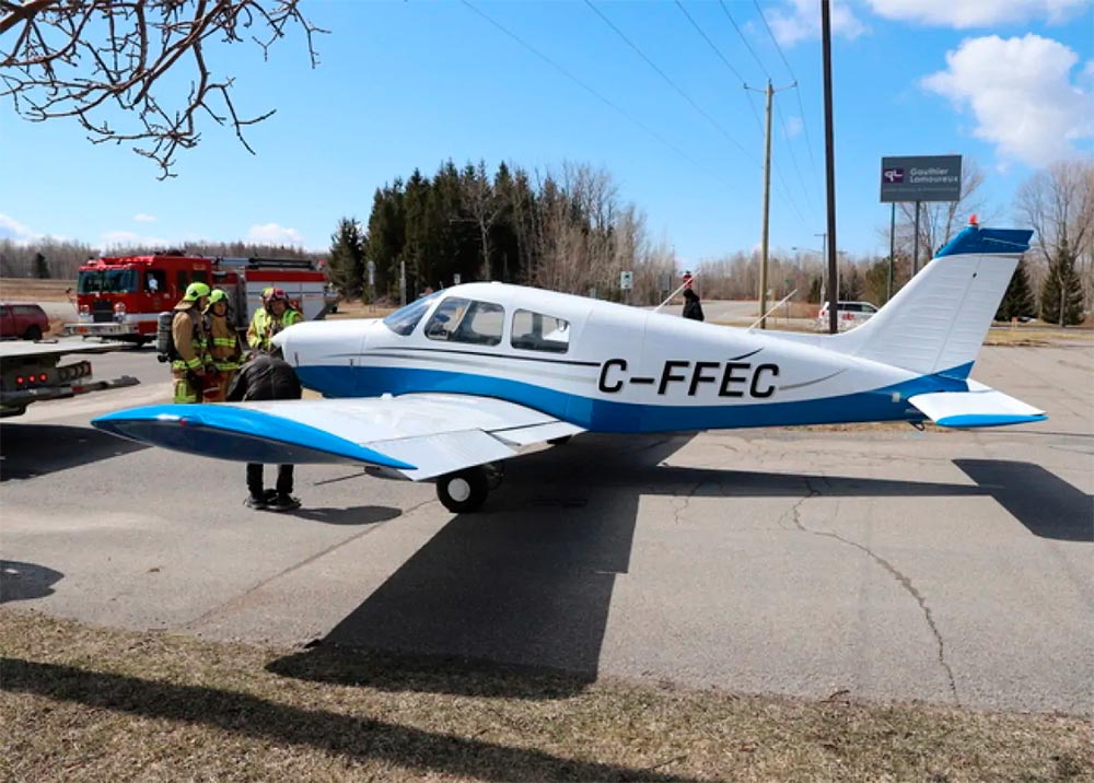
Reflexión: Cuando planifique un aterrizaje de emergencia en una carretera o autopista, considere siempre el aterrizar a favor del tránsito vehicular
martes, 4 de agosto de 2020
Sombrío panorama para aerolíneas: tráfico aéreo no volverá a la normalidad hasta 2024
Martes 28 julio de 2020
Por Christian Leal
La información es de Agence France-Presse
Por Christian Leal
La información es de Agence France-Presse
El tráfico aéreo mundial deberá aguardar cuatro años para recuperar sus niveles previos a la pandemia viral, estimó el martes la Asociación Internacional de Transporte Aéreo (IATA).
“Estimamos que el nivel (de tráfico) de 2019 no se alcanzará hasta 2024, que es un año más tarde de lo que habíamos previsto anteriormente”, dijo Brian Pearce, director financiero de IATA, que destacó las incertidumbres sobre el levantamiento de las restricciones fronterizas.
La recuperación del número de vuelos fue más lento de lo previsto en mayo y junio, añadió, y el segundo semestre seguirá la misma tendencia.
Para 2020, la caída del volumen de vuelos será del 63%, en lugar del 55% previsto anteriormente.
“Las proyecciones dependen mucho de la manera como los países controlan el virus”, alertó.
Una vacuna contra la covid-19 podría mejorar la situación, ante la incapacidad de los gobiernos para controlar la pandemia, dijo.
La situación es particulamente sombría “para los viajes transatlánticos”, en los que no se está produciendo una reapertura masiva de vuelos.
La organización, que agrupa 290 aerolíneas, estima que en 2020 el sector perderá 419.000 millones de dólares, lo que significa una caída de la mitad del volumen de negocios promedio.
lunes, 3 de agosto de 2020
domingo, 2 de agosto de 2020
sábado, 1 de agosto de 2020
Suscribirse a:
Entradas (Atom)